[COM] M2 Northern Connector | 15.5km | $867m
-
victorious80
- Gold-Member ;)
- Posts: 87
- Joined: Fri Jul 31, 2009 8:33 am
[COM] Re: Northern Connector | 14km | $1b
The latest design of the new Bolivar interchange has northern on and off ramps, as well as southern on and off ramps. ie all movements to and from the NC will be available at that interchange. Can only presume that it hasn't been released to public as not all approvals / agreements are in place?
[COM] Re: Northern Connector | 14km | $1b
I don't know. I haven't seen any plan or announcement that suggests that. It's certainly not on the DPTI website yet.victorious80 wrote:The latest design of the new Bolivar interchange has northern on and off ramps, as well as southern on and off ramps. ie all movements to and from the NC will be available at that interchange. Can only presume that it hasn't been released to public as not all approvals / agreements are in place?
It's also not clear that there will be right turns supported from Port Wakefield Road direct to Northern Expressway in any drawings I've seen. Do you know if the latest design has included that or it would require using the Waterloo Corner interchange?

[COM] Re: Northern Connector | 14km | $1b
A Power Point presentation from Aug 2016 had a full set of ramps for the Bolivar interchange. It's available from the following link under Industry Briefing.victorious80 wrote:The latest design of the new Bolivar interchange has northern on and off ramps, as well as southern on and off ramps. ie all movements to and from the NC will be available at that interchange. Can only presume that it hasn't been released to public as not all approvals / agreements are in place?
https://gateway.icn.org.au/project/3748 ... 1468345768
What give me confidence that this post-dates the currently public published design is that the southern interchange design is consistent with the more recent renders that have been publically published.
[COM] Re: Northern Connector | 14km | $1b
In the absence of a publically updated design, the area cleared for the Bolivar Road interchange should indicate whether or not it will have north-side ramps as this will require a wider cleared footprint immediately north of the interchange bridge site. Nearmap have updated their imagery to May 9 over part of Adelaide but this update doesn't as yet extend to the Northern Connector project footprint.
[COM] Re: Northern Connector | 14km | $1b
If you're going to the southern part of Paralowie, Mawson Lakes, Parafield Gardens or anywhere serviced by Elder Smith Drive or Montacute Rd, it makes more sense to use the NC and get off at Globe Derby as that way you avoid 4 sets of traffic lights, use a road which will likely be signposted as 110 (instead of 80/90 on PWR) and have no hassles with merging traffic from a number of unsignalised side roads (e.g. St Kilda Rd).SBD wrote:mawsonguy wrote:Where might I be coming from or going to that I would rather stay on the NC and swing out west to use a Globe Derby off ramp, rather than turn off onto Port Wakefield Road (which will have far less heavy traffic)?
[COM] Re: Northern Connector | 14km | $1b
I wouldn't put a lot of faith in those powerpoint slides. They also show a full interchange at Globe Derby which was eliminated in the July 2011 Project Impact Report. The SA government may live to regret that decission. It could have used the $150 million saving to build the Globe Derby interchange (or at least the bridge) and worry about connecting it up to Elder Smith Rd later. Now, when they want to do that, they will have to find the money for both the upgrade to Elder Smith Road and the construction of the interchange.drsmith wrote:A Power Point presentation from Aug 2016 had a full set of ramps for the Bolivar interchange. It's available from the following link under Industry Briefing.victorious80 wrote:The latest design of the new Bolivar interchange has northern on and off ramps, as well as southern on and off ramps. ie all movements to and from the NC will be available at that interchange. Can only presume that it hasn't been released to public as not all approvals / agreements are in place?
https://gateway.icn.org.au/project/3748 ... 1468345768
What give me confidence that this post-dates the currently public published design is that the southern interchange design is consistent with the more recent renders that have been publically published.
[COM] Re: Northern Connector | 14km | $1b
I remember this point being made when I first referenced the above Powerpoint presentation.mawsonguy wrote:I wouldn't put a lot of faith in those powerpoint slides. They also show a full interchange at Globe Derby which was eliminated in the July 2011 Project Impact Report.
By eliminated, do you mean eliminated (never to be built) or an ultimate design element that's not part of the upcoming build? This is an important distinction as while it's there in the above presentation, it's also shown not to be part of the upcoming build.
The key I think as to the currency of the above design is the southern interchange. Is the 2011 design to which you refer the following?
EDIT: The following is a link to the Fauna Report from 2011.
https://dpti.sa.gov.au/__data/assets/pd ... y_2011.PDF
Page 4 shows the interchange designs and shows no Globe Derby interchange and only a southbound on-ramp from Bolivar Road. The southern Interchange design also differs from that in the August 2016 presentation.
Last edited by drsmith on Thu May 18, 2017 8:38 pm, edited 1 time in total.
[COM] Re: Northern Connector | 14km | $1b
The unsignalised roads on the west will all be irrelevant, as none of them cross the Northern Connector, so only have a few farmers on each one (access to St Kilda will be from the Waterloo Corner Rd traffic lights, over the new bridge).mawsonguy wrote:If you're going to the southern part of Paralowie, Mawson Lakes, Parafield Gardens or anywhere serviced by Elder Smith Drive or Montacute Rd, it makes more sense to use the NC and get off at Globe Derby as that way you avoid 4 sets of traffic lights, use a road which will likely be signposted as 110 (instead of 80/90 on PWR) and have no hassles with merging traffic from a number of unsignalised side roads (e.g. St Kilda Rd).SBD wrote:Where might I be coming from or going to that I would rather stay on the NC and swing out west to use a Globe Derby off ramp, rather than turn off onto Port Wakefield Road (which will have far less heavy traffic)?
My comparison is the Northern Expressway in the area around Womma Road - when is it worth going out west as far as the Womma/Heaslip interchange, vs using Andrews Road or Peachey Road to reach the Curtis Road interchange to travel further north.
[COM] Re: Northern Connector | 14km | $1b
The Project Impact Report of July 2011 (https://www.infrastructure.sa.gov.au/__ ... y_2011.PDF) states "Globe Derby Park interchange removed from the scope of the project" and later "Room has been allowed for in the corridor for the construction of a future Globe Derby Park interchange, should the salt fields change to an urban expansions area".drsmith wrote:By eliminated, do you mean eliminated (never to be built) or an ultimate design element that's not part of the upcoming build? This is an important distinction as while it's there in the above presentation, it's also shown not to be part of the upcoming build.
So it appears that construction of the Globe Derby Interchange is not seen as a requirement in the near future.
[COM] Re: Northern Connector | 14km | $1b
Other than design detail, the treatment of the Globe Derby interchange is therefore consistent between the Project Impact Report of July 2011 and the August 2016 presentation above.
In the absence of further information otherwise, I therefore maintain my anticipation that the 2016 Bolivar interchange design above with all ramp movements is what will be built.
In the absence of further information otherwise, I therefore maintain my anticipation that the 2016 Bolivar interchange design above with all ramp movements is what will be built.
[COM] Re: Northern Connector | 14km | $1b
Google Earth has provided aerial shots of the Northern Connector corridor as at 6 April 2017.
Southern Interchange earthworks are progressing. You can start to see the shape of the on\off ramps.
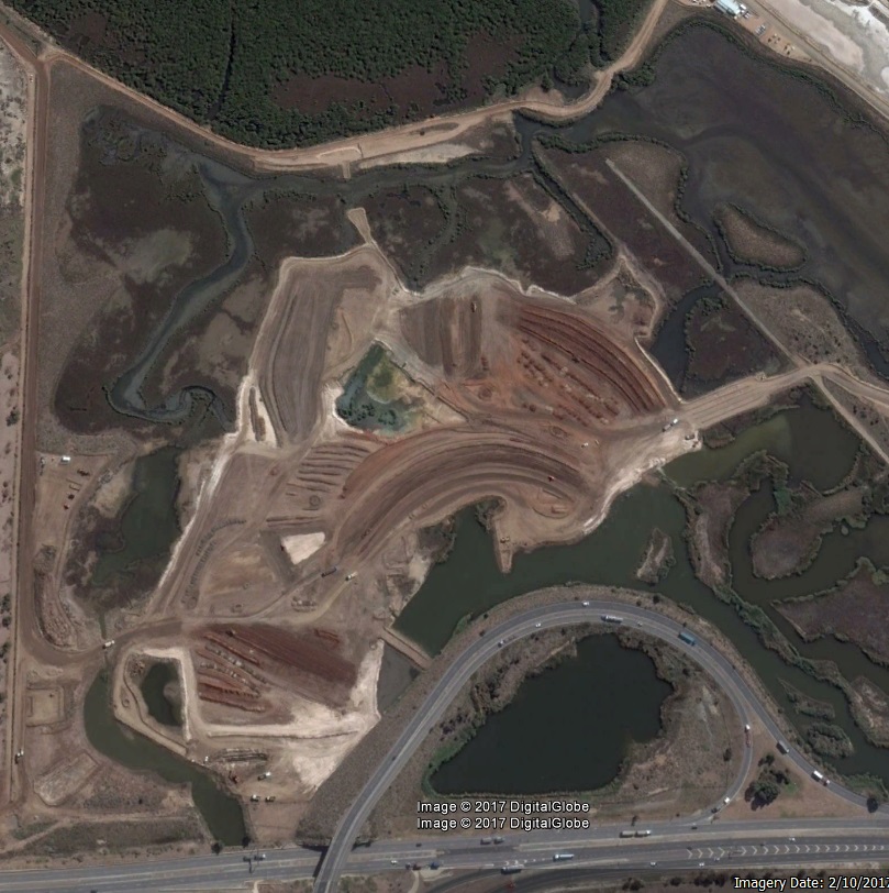
They are building a dirt road for truck access across the salt pans which appears to follow the NC alignment.
Southern Interchange earthworks are progressing. You can start to see the shape of the on\off ramps.
They are building a dirt road for truck access across the salt pans which appears to follow the NC alignment.
-
ChillyPhilly
- Super Size Scraper Poster!
- Posts: 2584
- Joined: Sun Dec 07, 2008 11:35 pm
- Location: Kaurna Land.
- Contact:
[COM] Re: Northern Connector | 14km | $1b
That 'dirt road' that follows the alignment would be part of the embankment.
Our state, our city, our future.
All views expressed on this forum are my own.
All views expressed on this forum are my own.
[COM] Re: Northern Connector | 14km | $1b
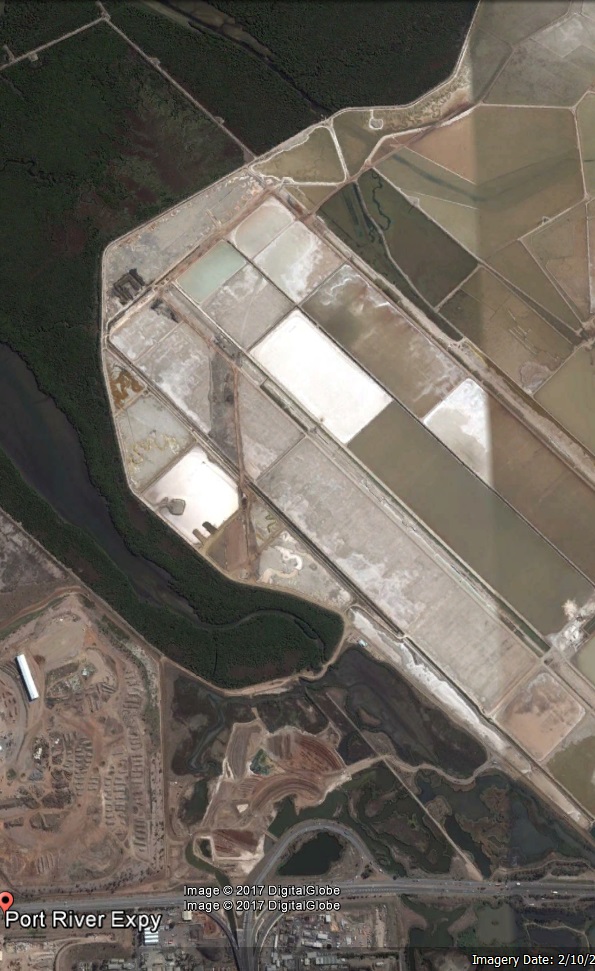
The ramp segments shown are broadly in line with 2 of 3 ramps in that area from the design in the August 2016 presentation.
Google Earth images from that date also extend through T2T and Darlington but don't quiet reach the Bolivar interchange area.
Google Earth images from that date also extend through T2T and Darlington but don't quiet reach the Bolivar interchange area.
-
Aaronlange
- Sen-Rookie-Sational
- Posts: 2
- Joined: Tue May 30, 2017 2:14 pm
[COM] Re: Northern Connector | 14km | $1b
Works ramping up at the waterloo corner interchange. One of the houses is being demolished to make way for the waterloo corner road extension
[COM] Re: Northern Connector | 14km | $1b
A May 21 Nearmap update shows that dirt road extending north almost to the northern end of the salt pans (as viewed at low resolution using their demo login).ChillyPhilly wrote:That 'dirt road' that follows the alignment would be part of the embankment.
Imagery for the above date doesn't as yet extend to the Bolivar interchange area.
Who is online
Users browsing this forum: Google [Bot] and 10 guests