Here's a refresher:


Cyclists and pedestrians aren't allowed to be on freeways & motorways.SBD wrote:Is that the current design? It shows the railway in the diagram, and has the south-to-west ramp different than other drawings I have seen that have it entering Salisbury Highway east of the current bridge.
Has anyone seen or heard "the plan" for how the bikeway/shared paths will cross Port Wakefield Road and Salisbury Highway? Are there bridges/underpasses/overpasses or will there just be "watch for bikes/pedestrians signs on the highways?
There's a separate path next to the Northern Expressway and there's a new 16km path proposed for the Connector. I imagine SBD is asking how they'll be connected.rev wrote:Cyclists and pedestrians aren't allowed to be on freeways & motorways.
Haven't you noticed the signs at the start of such roads that say they are prohibited to be on there?
Yes you're right I forgot about the paths.Splashmo wrote:There's a separate path next to the Northern Expressway and there's a new 16km path proposed for the Connector. I imagine SBD is asking how they'll be connected.rev wrote:Cyclists and pedestrians aren't allowed to be on freeways & motorways.
Haven't you noticed the signs at the start of such roads that say they are prohibited to be on there?
No.SBD wrote:Is that the current design?
Yes, I was asking about the connection from the current Stuart O'Grady Bikeway which ends on the east side of Port Wakefield Road to the new path along the Northern Connector, and between the southern end of the new path to both the westbound shoulder of Salisbury Highway/Port River Expressway and the paths at ground level under the South Road Superway. Both crossings are drawn on most planning maps with straight lines across the roads, but I have not seen any indication of whether there will be bridges, underpasses, or just "bikes crossing" and "watch for pedestrians" signs. Different versions of the drawings have slight variations on where these lines are drawn, so somebody must be thinking about it, but I have not seen anything authoritative. The closest I saw was the version that showed the Stuart O'Grady Bikeway extended parallel to PWR to Heaslip Road, then cross with the traffic lights there, but that has gone from the latest drawings and returned to a straight crossing at the south side of the northern interchange.Splashmo wrote:There's a separate path next to the Northern Expressway and there's a new 16km path proposed for the Connector. I imagine SBD is asking how they'll be connected.rev wrote:Cyclists and pedestrians aren't allowed to be on freeways & motorways.
Haven't you noticed the signs at the start of such roads that say they are prohibited to be on there?
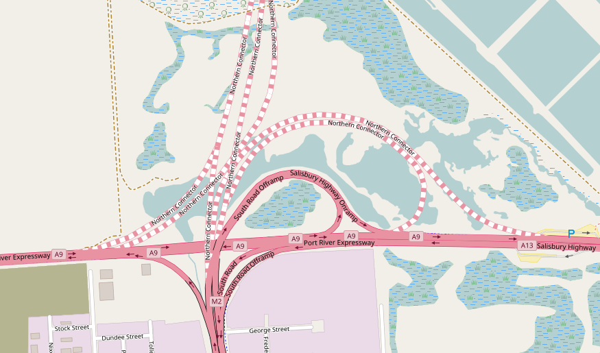
The top-right corner of the image aptly indicates the grains of salt with which OpenStreetMaps should be read.ChillyPhilly wrote:This is OpenStreetMap's layout:

Westside wrote:The top-right corner of the image aptly indicates the grains of salt with which OpenStreetMaps should be read.ChillyPhilly wrote:This is OpenStreetMap's layout:
Good call.Westside wrote:The top-right corner of the image aptly indicates the grains of salt with which OpenStreetMaps should be read.ChillyPhilly wrote:This is OpenStreetMap's layout:

I've been trying to figure out what exactly they're doing with the PRExy median. In two spots, it's been removed and replaced with bitumen. A future u-turn spot for when they demolish the existing interchange, perhaps? This makes sense with the westernmost clearing, between South Road and Hanson Road, but the eastern median clearing doesn't fit this theory.rev wrote:Not sure if anyone's posted this already but at the northern end of the superway, where the NC will run, work is well underway.
Users browsing this forum: Ahrefs [Bot] and 42 guests