Yes but it's not ONLY about the 3 extra stops is it? I agree, the expense of a light rail for three extra stops alone seems ridiculous, however it is also about getting people to use PT to the airport. As we already know, buses have not proven popular in transporting people to the airport. Buses have limited capacity. Putting a dedicated bus route with 3 intermediate stops would be a start, but would not also result in serious urbanisation of the corridor, as that would then require more buses, which would cause more congestion than longer light rail vehicles. It really depends if we want to continue with a low density city, serviced by buses, cars and taxis, or a higher density city, building up around a transport network already in place rather than keep trying to squeeze it in afterward.rubberman wrote: ↑Thu Sep 13, 2018 2:30 pmYeah, but is taking two lanes off Henley Beach Road for just serving three stops even an option? Probably not. Is it worth it for SDBD? Just for three stops? The answer to that is to make the consortium pay for the infrastructure, pay for the road real estate and take the risk. Taking two lanes out of a major road is a big cost and inconvenience. Unless the cost and inconvenience of taking two lanes out of SDBD is exceeded by the benefit of the extra traffic down SDBD, it's simply not worth it.
I'm not saying you are wrong btw, because we don’t have the numbers. However, it's certainly not clear enough to be definite either way unless we know if the benefit of extra traffic to the three stops in SDBD is greater than the cost of that lost two lanes. It's simply not possible to decide without having those numbers.
News & Discussion: Trams
Re: News & Discussion: Trams
Re: News & Discussion: Trams
The J1 and especially J1X to/from the airport are quite popular. I would suggest the only reason it isn't as popular as the SkyBus in Melbourne (obviously relative to size of the airport) is the cheap taxi fares to the CBD.claybro wrote: ↑Thu Sep 13, 2018 2:44 pmYes but it's not ONLY about the 3 extra stops is it? I agree, the expense of a light rail for three extra stops alone seems ridiculous, however it is also about getting people to use PT to the airport. As we already know, buses have not proven popular in transporting people to the airport. Buses have limited capacity. Putting a dedicated bus route with 3 intermediate stops would be a start, but would not also result in serious urbanisation of the corridor, as that would then require more buses, which would cause more congestion than longer light rail vehicles. It really depends if we want to continue with a low density city, serviced by buses, cars and taxis, or a higher density city, building up around a transport network already in place rather than keep trying to squeeze it in afterward.rubberman wrote: ↑Thu Sep 13, 2018 2:30 pmYeah, but is taking two lanes off Henley Beach Road for just serving three stops even an option? Probably not. Is it worth it for SDBD? Just for three stops? The answer to that is to make the consortium pay for the infrastructure, pay for the road real estate and take the risk. Taking two lanes out of a major road is a big cost and inconvenience. Unless the cost and inconvenience of taking two lanes out of SDBD is exceeded by the benefit of the extra traffic down SDBD, it's simply not worth it.
I'm not saying you are wrong btw, because we don’t have the numbers. However, it's certainly not clear enough to be definite either way unless we know if the benefit of extra traffic to the three stops in SDBD is greater than the cost of that lost two lanes. It's simply not possible to decide without having those numbers.
Re: News & Discussion: Trams
This is the crux of whether or not trams are viable for the airport or not.
For most other airports in Australia (perhaps with the exception of Sydney), an airport to CBD taxi fare would be over $50, and probably closer to $100 in Melb. In Adelaide, it's what ... about $25? With multiple travellers, that cost is shared. And with the exception of morning peak, you would be at your hotel in about 15-20 mins.
In Sydney, it could take up to one hour to get to your CBD hotel by taxi, despite the relatively short 8km distance. Hence a 10 min train ride starts looking like an attractive alternative.
In Adelaide, the economics and practicality argument doesn't strongly support public transport to the airport in Adelaide. I'm not saying it shouldn't be considered, but it's hard to build a strong business case for it.
-
rubberman
- Super Size Scraper Poster!
- Posts: 1759
- Joined: Tue Sep 04, 2007 10:32 pm
- Location: ADL ex DRW, ASP, MGB
Re: News & Discussion: Trams
Well, that's kinda the point. Getting people to the airport.claybro wrote: ↑Thu Sep 13, 2018 2:44 pmYes but it's not ONLY about the 3 extra stops is it? I agree, the expense of a light rail for three extra stops alone seems ridiculous, however it is also about getting people to use PT to the airport. As we already know, buses have not proven popular in transporting people to the airport. Buses have limited capacity. Putting a dedicated bus route with 3 intermediate stops would be a start, but would not also result in serious urbanisation of the corridor, as that would then require more buses, which would cause more congestion than longer light rail vehicles. It really depends if we want to continue with a low density city, serviced by buses, cars and taxis, or a higher density city, building up around a transport network already in place rather than keep trying to squeeze it in afterward.rubberman wrote: ↑Thu Sep 13, 2018 2:30 pmYeah, but is taking two lanes off Henley Beach Road for just serving three stops even an option? Probably not. Is it worth it for SDBD? Just for three stops? The answer to that is to make the consortium pay for the infrastructure, pay for the road real estate and take the risk. Taking two lanes out of a major road is a big cost and inconvenience. Unless the cost and inconvenience of taking two lanes out of SDBD is exceeded by the benefit of the extra traffic down SDBD, it's simply not worth it.
I'm not saying you are wrong btw, because we don’t have the numbers. However, it's certainly not clear enough to be definite either way unless we know if the benefit of extra traffic to the three stops in SDBD is greater than the cost of that lost two lanes. It's simply not possible to decide without having those numbers.
So the most likely increase in usage is from Airport centric passengers. That is, from the city hotel circuit to the airport. From the perspective of increasing traffic to and from the airport, why is a tram along SDBD superior to the Keswick route. Would it be faster? Will anybody from the 3 stops along SDBD want to go to the airport?
If you want people living along the line to use the tram, it would be to go to the city. However to get people to use it, you need possibly 10-12 stops at least. If you have that many stops, it's going to make the airport trip longer, and thus have zero advantage over taxis.
So, logically, it's either a fast service, limited stops (or no stops outside the CBD) so that it beats taxis. In this case, the drain route looks very good. Or, it's a multi-stop slower service which may get more passengers from the local area wanting to go into town, but simply won't be as attractive to airport travellers because it won't be that much better than buses, if at all.
I can't see how you can get extra passengers from the local traffic AND have a really fast airport link. Choose one.
-
1NEEDS2POST

- High Rise Poster!
- Posts: 471
- Joined: Tue Jun 26, 2018 5:01 pm
Re: News & Discussion: Trams
Every time I've taken the bus to and from the airport, there are empty seats. Even during peak hour, the double decker buses cope.claybro wrote: ↑Thu Sep 13, 2018 2:44 pmYes but it's not ONLY about the 3 extra stops is it? I agree, the expense of a light rail for three extra stops alone seems ridiculous, however it is also about getting people to use PT to the airport. As we already know, buses have not proven popular in transporting people to the airport. Buses have limited capacity. Putting a dedicated bus route with 3 intermediate stops would be a start, but would not also result in serious urbanisation of the corridor, as that would then require more buses, which would cause more congestion than longer light rail vehicles. It really depends if we want to continue with a low density city, serviced by buses, cars and taxis, or a higher density city, building up around a transport network already in place rather than keep trying to squeeze it in afterward.
The difference between light rail and buses in generating congestion is insignificant here. We're talking about one route that gets a vehicle every ten minutes.
There is a trade off, but it's somewhat offset by the fact that people will walk further to good quality public transport.
Passengers will walk up to a kilometre for rapid transit, and about 400 m for a regular bus. I'm getting these figures from one of my favourite bloggers https://humantransit.org/2010/11/san-fr ... -plan.html
Keswick Creek drain is about 300 m from SDB, putting it within walking distance. Furthermore, I'd imagine that the Eastern end of the drain route would use James Congdon Drive. It's wide enough to put a tram down the centre. (Coincidentally it used to be a railway line.) It also brings the route closer to SDB and the shops around there.
-
how good is he
- Legendary Member!
- Posts: 1233
- Joined: Thu Jan 24, 2013 1:26 am
-
1NEEDS2POST
- High Rise Poster!
- Posts: 471
- Joined: Tue Jun 26, 2018 5:01 pm
Re: News & Discussion: Trams
Keswick Creek stormwater drain was constructed initially in the 1930s to prevent flooding in the Western suburbs. In the 1950s it was reconfigured for the airport. The drain could be put underneath light rail tracks. It looks wide enough for two light rail tracks along most of the proposed routes. There are a few tight spots though. Fortunately the loading gauge of Adelaide trams is narrow.
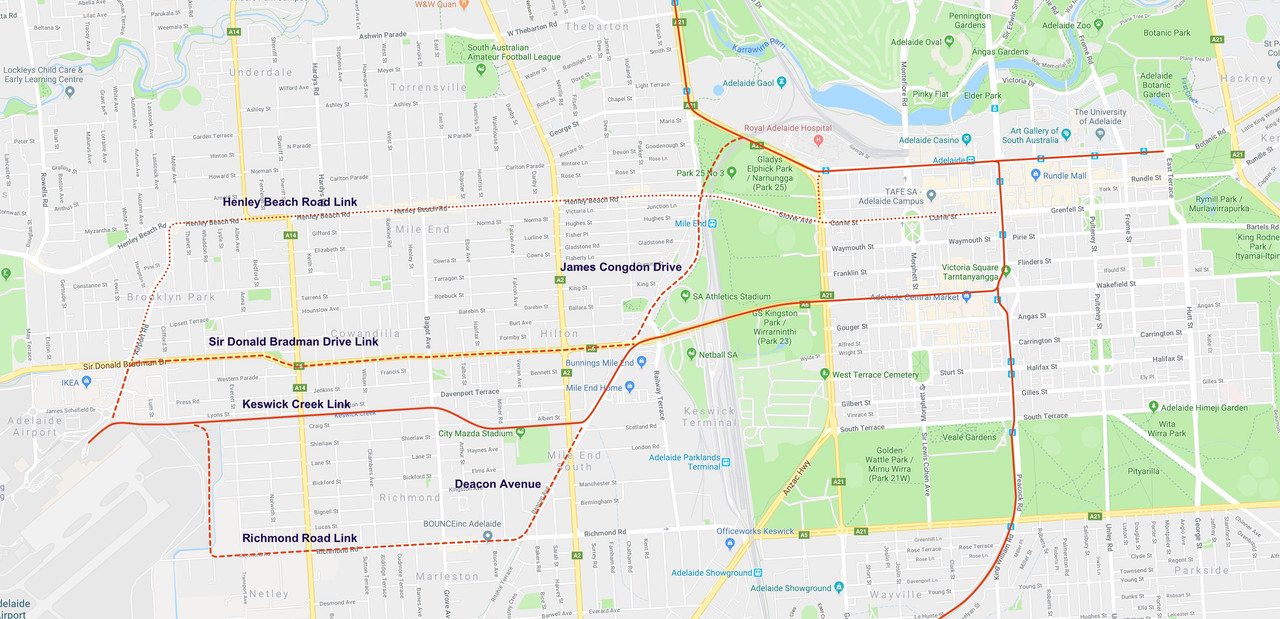
This is the route I have in mind, from the airport boundary to West Terrace:

Blue is where the tracks are on top of the drain. Red is where it would travel on roads. Where the drain crosses James Congdon Drive, the median is quite large. From there, trams could travel in the median to SDB, where again the road could take trams in the median, all the way into the city.
This is the route I have in mind, from the airport boundary to West Terrace:
Blue is where the tracks are on top of the drain. Red is where it would travel on roads. Where the drain crosses James Congdon Drive, the median is quite large. From there, trams could travel in the median to SDB, where again the road could take trams in the median, all the way into the city.
-
Ho Really

- Super Size Scraper Poster!
- Posts: 2675
- Joined: Sun Aug 27, 2006 3:29 pm
- Location: In your head
Re: News & Discussion: Trams
Fellas, here are most of the solutions that have been suggested under this topic. Including the Keswick Creek that I suggested years ago.how good is he wrote: ↑Thu Sep 13, 2018 8:40 pmCan someone post the map/route of the Keswick Creek drain to show?
My preference is not marked on this map and it is not a light rail option. From the Airport it uses the Keswick Creek to City Mazda Stadium (old Richmond Oval). From there it goes underground linking the Adelaide Parklands Terminal and then into the city as an underground railway or the option, again underground, resurfacing before the Mile End station and continuing to Adelaide Station. My solution is one part of an underground system in the city which does not include the famous loop, but a different and more practical solution, albeit expensive. But if Adelaide wants to be a city with a vision that's what it needs to do.
Cheers
P.S. I'll post other maps under a different topic later. Working on many options.
Confucius say: Dumb man climb tree to get cherry, wise man spread limbs.
Re: News & Discussion: Trams
It's worth keeping in mind that Keswick Creek is currently being upgraded as part of a ~$200 million dollar scheme to manage & mitigate flood risk through the inner southern suburbs over the next few decades. There's a 388 page master plan from 2016 detailing the upgrades at the project website: https://bhkcstormwater.com.au/. Future tramlines are not mentioned anywhere in the report. However it is noted that covering the creek to create a linear walking path is not very feasible, mainly because covering the creek is inconsistent with best practice for the catchment (there are serious risks when floodwater exceeds the capacity of a covered system, or blockages occur etc), but also because large parts of the creek between the airport and the city are on private property.
-
Ho Really
- Super Size Scraper Poster!
- Posts: 2675
- Joined: Sun Aug 27, 2006 3:29 pm
- Location: In your head
Re: News & Discussion: Trams
Without going off track (no pun intended), haven't they already done work on part of the catchment and diverted water from the Keswick Creek down Brownhill Creek?Listy wrote: ↑Thu Sep 13, 2018 11:39 pmIt's worth keeping in mind that Keswick Creek is currently being upgraded as part of a ~$200 million dollar scheme to manage & mitigate flood risk through the inner southern suburbs over the next few decades. There's a 388 page master plan from 2016 detailing the upgrades at the project website: https://bhkcstormwater.com.au/. Future tramlines are not mentioned anywhere in the report. However it is noted that covering the creek to create a linear walking path is not very feasible, mainly because covering the creek is inconsistent with best practice for the catchment (there are serious risks when floodwater exceeds the capacity of a covered system, or blockages occur etc), but also because large parts of the creek between the airport and the city are on private property.
If tracks are laid over the drain they will be on a raised platform leaving ample room for overflow should that happen.
As for private property do you know exactly where that is?
Thanks for your input.
Cheers
Confucius say: Dumb man climb tree to get cherry, wise man spread limbs.
Re: News & Discussion: Trams
It's also worth adding that the Keswick creek goes underneath many suburban streets. Is the proposal from those suggesting using the creek to build a ton of overpasses or signalled crossings on them?
Re: News & Discussion: Trams
You raised an interesting point in your reply Ho. And thanks for the maps BTW. If a Keswick creek had to be on raised track because of the drain, you would then need to wall in the backyards of every house along the creek through Richmond/Cowandilla to prevent loss of privacy of those properties. I would imagine those along that stretch would seek some compensation for their loss of amenity, and maybe some loss of land due to large footings etc. Parts of the creek reserve, while wide enough for laying of standard tracks, digging large foundations to support a raised track system is another point entirely. From you map, it would appear the most direct route is the SBD route straight along Grote street to Vic Square to join the existing CBD track.Ho Really wrote: ↑Thu Sep 13, 2018 11:57 pmWithout going off track (no pun intended), haven't they already done work on part of the catchment and diverted water from the Keswick Creek down Brownhill Creek?Listy wrote: ↑Thu Sep 13, 2018 11:39 pmIt's worth keeping in mind that Keswick Creek is currently being upgraded as part of a ~$200 million dollar scheme to manage & mitigate flood risk through the inner southern suburbs over the next few decades. There's a 388 page master plan from 2016 detailing the upgrades at the project website: https://bhkcstormwater.com.au/. Future tramlines are not mentioned anywhere in the report. However it is noted that covering the creek to create a linear walking path is not very feasible, mainly because covering the creek is inconsistent with best practice for the catchment (there are serious risks when floodwater exceeds the capacity of a covered system, or blockages occur etc), but also because large parts of the creek between the airport and the city are on private property.
If tracks are laid over the drain they will be on a raised platform leaving ample room for overflow should that happen.
As for private property do you know exactly where that is?
Thanks for your input.
Cheers
Re: News & Discussion: Trams
Only half-joking, the best solution if you really wanted an affordable rapid public transport link directly to the airport would probably be a monorail down SDB.
Re: News & Discussion: Trams
I think a lot of work is complete, but the culvert itself is in need of remediation in places according to the report & I don't think that's happened?Ho Really wrote: ↑Thu Sep 13, 2018 11:57 pmWithout going off track (no pun intended), haven't they already done work on part of the catchment and diverted water from the Keswick Creek down Brownhill Creek?Listy wrote: ↑Thu Sep 13, 2018 11:39 pmIt's worth keeping in mind that Keswick Creek is currently being upgraded as part of a ~$200 million dollar scheme to manage & mitigate flood risk through the inner southern suburbs over the next few decades. There's a 388 page master plan from 2016 detailing the upgrades at the project website: https://bhkcstormwater.com.au/. Future tramlines are not mentioned anywhere in the report. However it is noted that covering the creek to create a linear walking path is not very feasible, mainly because covering the creek is inconsistent with best practice for the catchment (there are serious risks when floodwater exceeds the capacity of a covered system, or blockages occur etc), but also because large parts of the creek between the airport and the city are on private property.
If tracks are laid over the drain they will be on a raised platform leaving ample room for overflow should that happen.
As for private property do you know exactly where that is?
Thanks for your input.
Cheers
If you look at the location SA mapping website, it appears the creek runs through land owned by several businesses in Mile End. There's also a bend near the football stadium where the culvert is only about 4-5m wide, and it's actually running though residential backyards, presumably with significant easements. It looks like there are brand new battleaxe housing subdivisions with houses & units built right up against the edge of the culvert to contend with too.
Re: News & Discussion: Trams

But I digress
There's a third option of having 2 lines, one down SDBD and one down Henley Beach Road

Dream bigger than a Point A to Point B tram line from the Airport and just connect the airport to a larger network
Who is online
Users browsing this forum: Amazon [Bot] and 48 guests