claybro wrote:Conversion of the Outer Harbour line to light rail would be viable if
1. Grange Line also converted.
2. West Lakes extension completed.
3. Semaphore and Port Adelaide extension completed.
This would bring the business centres of Port Adelaide, Semaphore and West Lakes into the system, and better utilise the Woodvill/City corridor.
It would greatly increase frequency along the Woodville/City section (the current train frequency is poorly patronsied and the frequency is pathetic)
The only downside...Those commuters on the LeFevre pensinsula would have a much longer journey than is currently the case.
The other question is if the operators have the balls to speed the system up to get best efficiency as they are far from having it right even on the Glenelg Line.
The existing heavy rail is not really viable in its current setup.
[Shuz] wrote:As a daily user of the Outer Harbour line, it really should be light rail. There simply isnt the patronage to support heavy rail. Ever. Better to have tram lines branched off to Grange, Semaphore, and West Lakes.
I'm a little surprised that people only talk about light rail as the solution for the Outer Harbour line. I've been reading a lot about the topic of light rail transit vs bus rapid transit/busways (BRT), and I'm increasingly convinced that a BRT system is the most practical and cost-effective option to provide a modern transport service for the north-western suburbs (which are low-density and will always be low-density by global standards).
This web link below shows the key features of a BRT system:
https://www.itdp.org/library/standards- ... at-is-brt/
You will notice that these are the exact same features you would expect to find in a modern light rail/tram system. Hence a well-designed BRT offers the same benefits of light rail at a fraction of the cost.
Granted the ride may not be quite as comfortable as light rail, but is it worth paying 2 or 3 times the cost for a slightly better ride? Or additional passenger capacity (an advantage of light rail) which may never be required?
Example of application ... WestLINK and EastLINK (described below) would probably look like this:
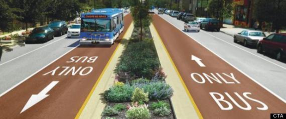
The two biggest advantages of BRT are cost and route flexibility.
Cost: With the spiralling cost of light rail over the past decade, capital costs of BRT's are typically between 30-50% of those of light rail …. a huge saving of hundreds of millions for our cash-strapped state. Increased affordability of the system means we most likely won't have to wait decades for it to be implemented.
Interesting in Perth, their light rail project now looks likely to be abandoned in favour of a more cost -effective BRT system. The cost of their 22km light rail project was expected to be $2.5B. The BRT system is expected to be half the cost. If Perth can’t afford light rail of decent length, Adelaide has even less hope.
Flexibility: On the Outer Harbour line, multiple bus routes from other locations such as Addison Rd, Hanson Rd, Days Rd etc can feed into the busway alignment to provide a fast service into the city, with NO TRANSFERS required. In effect, it would operate with a similar level of flexibility as the O-bahn.
PortLINK busway
The PortLINK busway would basically utilise the existing railway alignment to Outer Harbour, the major exception being in Port Adelaide where it would deviate onto Commercial Rd and St Vincent St to provide a better located stations in the heart of Port Adelaide.
There would also be a busway alignment to Grange (along existing railway alignment), West Lakes (in median of West Lakes Blvd … partly in place already) and Semaphore (new alignment in median of Semaphore Rd).
Bus stops/platforms would be located roughly where the existing railway stations are, but would have similar design to the existing tram stops in the city. Passing lanes could be created at stops between Woodville and the city, thereby allowing the possibility of express services to the city with Port Adelaide-Woodville-Bowden being the high-service express stops.
At the city end, the busway would continue from Bowden through the parklands (along the existing rail corridor), however then divert onto Gaol Rd (next to Adelaide Gaol) and then link into Port Rd, thereby avoiding the major intersections of Port Rd/Park Tce and Port Rd/James Congdon Dr. Then along North Tce, it can use the existing tram lane, thereby making more efficient use of this lane.
WestLINK and EastLINK busway
For similar reasons to the above, I believe the proposed WestLINK (to Henley Beach) and EastLINK (to Uni SA at Magill) would work better as median-aligned busways as they serve low-density suburbs with no major activity centres along the route.
The busway would then be a higher-speed portal to the CBD for other surrounding bus services in the catchment area. Eg Magill and Rostrevor bus routes could also feed into the EastLINK busway rather than go along Magill Rd to the city (as they currently do). This would be a much faster service into the CBD.
These buses would also need to be fitted with left and right-side opening doors (like a tram) so they can used along the busway as well as ‘normal’ bus stops beyond the busway. Bus stops/platforms would have similar design to the existing tram stops in the city, and be spaced approx. 800m - 1km apart to speed up service.
NorthLINK busway
Finally, I’d propose a median-aligned NorthLINK busway along Main North Rd to Gepps Cross, instead of the tramline along Prospect Rd. This would then provide a higher-speed portal to the CBD for other surrounding bus services in the catchment area such as Ingle Farm, Pooraka, Para Hills etc.
In addition, the road width of Main North Rd is more capable of absorbing a bus lane in each direction than Prospect Rd.