[U/C] Re: Victoria Tower - 36 Grote Street | 120m | 37 levels | apartments
Posted: Tue Feb 18, 2025 8:45 am
Southern core is rising again.

Adelaide's Premier Development and Construction Site
https://sensational-adelaide.com/forum/
The GE data is consistent with topographical mapping and survey mark data for the vicinities of Victoria and RAA towers. These all give a ground elevation of 44m. This can be seen for example in the Plan SA Property and Planning Atlas (SAPPA). Topographic mapping can be viewed by selecting "Topographic" instead of the default "Street Map" basemap option. Survey mark location and data can be viewed by enabling the "Survey Mark" layer.rocklicker78 wrote: ↑Sat Feb 15, 2025 1:49 pmI understood what he meant, elevation is an important aspect in my job. Still, it doesn't look that much elevation difference from a pedestrian pov... although in Google Earth there is a 30 metres elevation, so I guess Shuz could be right and there is a significant elevation at the RAA Tower compared with the ground where Victoria Tower is rising. EDIT: My bad, only 1 metre difference on Google Earth, although GE is not the best place to check accurate elevations.rev wrote: ↑Sat Feb 15, 2025 11:11 amWhat he's talking about is the ground level. I can't remember the abbreviation for the measurement they use, but I'm sure Shuz will elaborate on that.rocklicker78 wrote: ↑Sat Feb 15, 2025 8:42 am
From what I understand, the RAA Tower is 132 (131.6m) metres height, so it will be about 9-10 metres higher when Victoria Tower tops up. So, not the same height although the difference is not huge the RAA Tower will still be higher. Unlesss you are talking about a different way to measure them?
In addition, from the pov of the latest photo, the RAA Tower is closer, so it will look higher.
The ground level difference seems to me to be no more than 5 metres, but yeah I think the RAA Tower is on higher ground.
Imagine the RAA building is built on a small hill, and Victoria Tower is built in the small valley next to it. Although from memory I think they refer to above sea level. But Shuz will probably give you a better explanation.
The link you posted to the topographic-map site indicates that it is based on the TessaDEM database. How good is the accuracy of the DEM in heavily urbanised areas, given the seeming discrepancies in ground elevation from DEM and topographic sources? The topographic-map data shows considerable variation in elevation in the central CBD from 56m at Victoria Tower to almost 90m around Telstra Tower ove a distance of 450m. The derivation of a ground elevation model from the original remote survey data seems to involve quite sophisticated data processing.[Shuz] wrote: ↑Sun Feb 16, 2025 8:16 amThis is regarded as a reliable source for topographic elevation maps in South Australia.
https://en-au.topographic-map.com/map-w ... Australia/
If you click the map on the Victoria Tower site, the elevation is 56 metres above sea level.
The elevation at the RAA Tower site is 68 metres above sea level.
A difference of 14 metres.
...
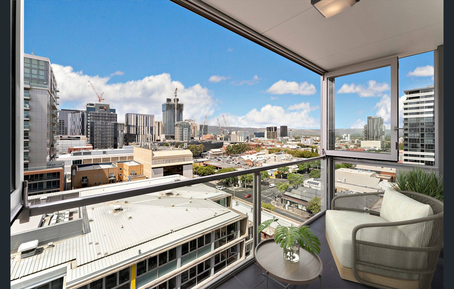
The development on the former bus station will nicely fill that area in that shot.

Thank you for touching base on this, I noticed those huge variations as well on the source that Shuz shared, with a variation of 15 metres from one road to another a parallel road, that, by the look of it, and lack of technical information I would say that it is definitely not a reliable source. But not keen on arguing.PD2/20 wrote: ↑Tue Feb 18, 2025 11:07 amThe GE data is consistent with topographical mapping and survey mark data for the vicinities of Victoria and RAA towers. These all give a ground elevation of 44m. This can be seen for example in the Plan SA Property and Planning Atlas (SAPPA). Topographic mapping can be viewed by selecting "Topographic" instead of the default "Street Map" basemap option. Survey mark location and data can be viewed by enabling the "Survey Mark" layer.rocklicker78 wrote: ↑Sat Feb 15, 2025 1:49 pmI understood what he meant, elevation is an important aspect in my job. Still, it doesn't look that much elevation difference from a pedestrian pov... although in Google Earth there is a 30 metres elevation, so I guess Shuz could be right and there is a significant elevation at the RAA Tower compared with the ground where Victoria Tower is rising. EDIT: My bad, only 1 metre difference on Google Earth, although GE is not the best place to check accurate elevations.rev wrote: ↑Sat Feb 15, 2025 11:11 am
What he's talking about is the ground level. I can't remember the abbreviation for the measurement they use, but I'm sure Shuz will elaborate on that.
Imagine the RAA building is built on a small hill, and Victoria Tower is built in the small valley next to it. Although from memory I think they refer to above sea level. But Shuz will probably give you a better explanation.The link you posted to the topographic-map site indicates that it is based on the TessaDEM database. How good is the accuracy of the DEM in heavily urbanised areas, given the seeming discrepancies in ground elevation from DEM and topographic sources? The topographic-map data shows considerable variation in elevation in the central CBD from 56m at Victoria Tower to almost 90m around Telstra Tower ove a distance of 450m. The derivation of a ground elevation model from the original remote survey data seems to involve quite sophisticated data processing.[Shuz] wrote: ↑Sun Feb 16, 2025 8:16 amThis is regarded as a reliable source for topographic elevation maps in South Australia.
https://en-au.topographic-map.com/map-w ... Australia/
If you click the map on the Victoria Tower site, the elevation is 56 metres above sea level.
The elevation at the RAA Tower site is 68 metres above sea level.
A difference of 14 metres.
...
The comments on topographic mapping and survey marks in the second half of my post are in relation to the SA Property and Planning Atlas (https://sappa.plan.sa.gov.au/), which I discovered as a convenient access to topographic and survey mark data.rocklicker78 wrote: ↑Sat Feb 22, 2025 1:15 pmThank you for touching base on this, I noticed those huge variations as well on the source that Shuz shared, with a variation of 15 metres from one road to another a parallel road, that, by the look of it, and lack of technical information I would say that it is definitely not a reliable source. But not keen on arguing.PD2/20 wrote: ↑Tue Feb 18, 2025 11:07 amThe GE data is consistent with topographical mapping and survey mark data for the vicinities of Victoria and RAA towers. These all give a ground elevation of 44m. This can be seen for example in the Plan SA Property and Planning Atlas (SAPPA). Topographic mapping can be viewed by selecting "Topographic" instead of the default "Street Map" basemap option. Survey mark location and data can be viewed by enabling the "Survey Mark" layer.rocklicker78 wrote: ↑Sat Feb 15, 2025 1:49 pm
I understood what he meant, elevation is an important aspect in my job. Still, it doesn't look that much elevation difference from a pedestrian pov... although in Google Earth there is a 30 metres elevation, so I guess Shuz could be right and there is a significant elevation at the RAA Tower compared with the ground where Victoria Tower is rising. EDIT: My bad, only 1 metre difference on Google Earth, although GE is not the best place to check accurate elevations.The link you posted to the topographic-map site indicates that it is based on the TessaDEM database. How good is the accuracy of the DEM in heavily urbanised areas, given the seeming discrepancies in ground elevation from DEM and topographic sources? The topographic-map data shows considerable variation in elevation in the central CBD from 56m at Victoria Tower to almost 90m around Telstra Tower over a distance of 450m. The derivation of a ground elevation model from the original remote survey data seems to involve quite sophisticated data processing.[Shuz] wrote: ↑Sun Feb 16, 2025 8:16 amThis is regarded as a reliable source for topographic elevation maps in South Australia.
https://en-au.topographic-map.com/map-w ... Australia/
If you click the map on the Victoria Tower site, the elevation is 56 metres above sea level.
The elevation at the RAA Tower site is 68 metres above sea level.
A difference of 14 metres.
...
Thanks for the info on GE! I didn't know about the Topographic mapping option!
EDIT: Couldn't find the Topographic mapping option you mentioned, can you provide some instructions please?
