
http://maps.google.com/maps/ms?ie=UTF8& ... 87547&z=14
Still have to work on the Willunga (Tonsley) and Buckland Park (Northern Connector) lines, but the rest of the system is pretty well done by now.
Roads & Rail
-
Wilfy 2007
- High Rise Poster!
- Posts: 122
- Joined: Sun Nov 25, 2007 6:54 pm
Re: Roads & Rail
Hi Shuz,Shuz wrote:http://maps.google.com/maps/ms?ie=UTF8& ... 87547&z=14
Still have to work on the Willunga (Tonsley) and Buckland Park (Northern Connector) lines, but the rest of the system is pretty well done by now.
Very impressed with you planned Railway lines.
Buckland Park, will you be planning to come into the northern end of the town centre of Buckland park.
Regards,
-
peas_and_corn
- Legendary Member!
- Posts: 522
- Joined: Thu Oct 30, 2008 9:32 pm
-
Somebody
- High Rise Poster!
- Posts: 252
- Joined: Fri May 02, 2008 6:06 pm
- Location: Australia (East Coast)
Re: Roads & Rail
Don't forget to include:
- New branch from Elizabeth South to Elizabeth East (there are houses so they need a train)
- Continuation of said Buckland Park line to Gawler via whatever farms are between. Make it as single track, and run it like Melbun's City Loop. Anti-clockwise before 12:30, then clockwise until last train. Weekends clockwise all day. This will ensure there is a fast trip to the city in the peak direction at all times
PM Peak (example): Adelaide - Salisbury - West Nurlutta - Buckland Park - Northwest Gawler - Gawler - Elizabeth - Salisbury - Adelaide
- Northfield line
- Dry Creek to Port Adelaide via Rosewater line
- New branch from Tea Tree Gully line to Rostrevor near the 104 bus terminus. Trains will run every 30mins M-F until 7pm, every 60 other times.
- Branch from Rostrevor line to Magill near the 110 terminus
- Reinstatement of the old Willunga route from Hallett Cove so they can go via two ways
Last edited by Somebody on Tue Feb 03, 2009 12:22 am, edited 1 time in total.
The Gold Coast - Australia's centre for insipid, tacky & boring.
Re: Roads & Rail
Well, thats just one of the rigours of my plan. There are no branch lines.
The Willunga (Tonsley) would have its own tracks, effectively quadrupling the Noarlunga rail corridor to Ascot Park station.
As would happen for the Virginia and Gawler lines, quadrupled. Between Victoria Sqaure and Goodwood interchange would be 6-track to include Belair lines. Between Adelaide Railway Station and Victoria Sqaure would be 8-track, in two sets of twin tube tunnels on 2 levels to accomodate the Mount Barker line.
I dont know if the on the main north-south lines (Noarlunga to Elizabeth, it should be quadrupled track to allow expres services to run, and for each deistnation to operate as satellite cities in their own entities,.
-
Somebody
- High Rise Poster!
- Posts: 252
- Joined: Fri May 02, 2008 6:06 pm
- Location: Australia (East Coast)
Re: Roads & Rail
How long will it take a train to get from Adelaide to Willunga via Tonsley? Why no branch lines? That's pretty much a branch.. :wank:
Also another one could be extension of the Northfield line to Wakley Heights, followed by Modbury and onto Golden Grove to provide a direct link from Dry Creek to the TTG area.
What do you have for the Hills? I'd go for a couple of railcars in peak at first.
Also another one could be extension of the Northfield line to Wakley Heights, followed by Modbury and onto Golden Grove to provide a direct link from Dry Creek to the TTG area.
What do you have for the Hills? I'd go for a couple of railcars in peak at first.
The Gold Coast - Australia's centre for insipid, tacky & boring.
Re: Roads & Rail
Finally! I came across a photo, which clearly identifies how I think the North-South route should be developed (if it is to take place of the South Road alignment)

By rob2655 of Flickr.
Set inground, but remains open-air. Side acess roads would still remain at ground level and have on-off ramps at all major intersections. It would allow for several bridges to be built over to connect all the side streets, which technically is a flawed obstacle to the 'traffic-light free' plan they currently have for south road, as this traffic would still continue to create minor congestion. Its a concept which would integrate will with the U/C anzac highway underpass and Sturt road underpass, and the Port/Grange road tunnel.
-
Somebody
- High Rise Poster!
- Posts: 252
- Joined: Fri May 02, 2008 6:06 pm
- Location: Australia (East Coast)
Re: Roads & Rail
Ya didn't answer me question, sport.
The Gold Coast - Australia's centre for insipid, tacky & boring.
Re: Roads & Rail
Sorry matey.Somebody wrote:Ya didn't answer me question, sport.
The track would be quadrupled from Adelaide to Ascot Park station, Aldinga services to operate on the northernmost 2 lines, Willunga services to operate on the two southernmost lines. Therefore it would not be a branch service of the Aldinga line, as they would be treated as seperate tracks (which just happen to share the same corridor for part of the journey). I'd estimate a Willunga service would take about 60-70 minutes into the City, stopping all stations. Express, it could take 30-40.Somebody wrote:How long will it take a train to get from Adelaide to Willunga via Tonsley? Why no branch lines? That's pretty much a branch.
Negative. I have a no-branch policy. Where 'branches' appear to exist, the corridor is quadrupled to the point where it branches off.Somebody wrote:Also another one could be extension of the Northfield line to Wakley Heights, followed by Modbury and onto Golden Grove to provide a direct link from Dry Creek to the TTG area.
I have contemplated reinstating the Northfield line, but not as a service into the City, but to Port Adelaide instead. That would encourage development in the area. I don't think its a highly feasible concept.
6 services an hour peak every 10 minutes. 3 services an hour off-peak, 1 service an hour night.Somebody wrote:What do you have for the Hills? I'd go for a couple of railcars in peak at first.
-
Somebody
- High Rise Poster!
- Posts: 252
- Joined: Fri May 02, 2008 6:06 pm
- Location: Australia (East Coast)
Re: Roads & Rail
That's alright 
Oh and I luuuv your hills services - 1 train an hour that takes twice as long as driving is yum
 . Connecting Mount Barker, SANZ to Adelaide, SANZ.
What's wrong with having shuttle services from teh junction to the branch?Shuz wrote:Negative. I have a no-branch policy. Where 'branches' appear to exist, the corridor is quadrupled to the point where it branches off.
Oh and I luuuv your hills services - 1 train an hour that takes twice as long as driving is yum
The Gold Coast - Australia's centre for insipid, tacky & boring.

Re: Roads & Rail
I can't see the pictureShuz wrote:Finally! I came across a photo, which clearly identifies how I think the North-South route should be developed (if it is to take place of the South Road alignment)
By rob2655 of Flickr.
Set inground, but remains open-air. Side acess roads would still remain at ground level and have on-off ramps at all major intersections. It would allow for several bridges to be built over to connect all the side streets, which technically is a flawed obstacle to the 'traffic-light free' plan they currently have for south road, as this traffic would still continue to create minor congestion. Its a concept which would integrate will with the U/C anzac highway underpass and Sturt road underpass, and the Port/Grange road tunnel.
-
Prince George
- Legendary Member!
- Posts: 974
- Joined: Wed Sep 10, 2008 11:02 pm
- Location: Melrose Park
Re: Roads & Rail
This is Flickr's new lightweight copyright protection for the users that have requested no-downloading of their images; each image that they display is layered behind this transparent GIF so when you click on the image to download it, you get the blank one instead. See http://flickr.com/help/forum/7362/.Cruise wrote:I can't see the pictureShuz wrote:Finally! I came across a photo, which clearly identifies how I think the North-South route should be developed (if it is to take place of the South Road alignment)
(Inserts Img link to http://l.yimg.com/g/images/spaceball.gif)
-
Aidan
- Super Size Scraper Poster!
- Posts: 2135
- Joined: Fri Dec 08, 2006 3:10 am
- Location: Christies Beach
Re: Roads & Rail
I'm guessing you mean this:Shuz wrote:Finally! I came across a photo, which clearly identifies how I think the North-South route should be developed (if it is to take place of the South Road alignment)
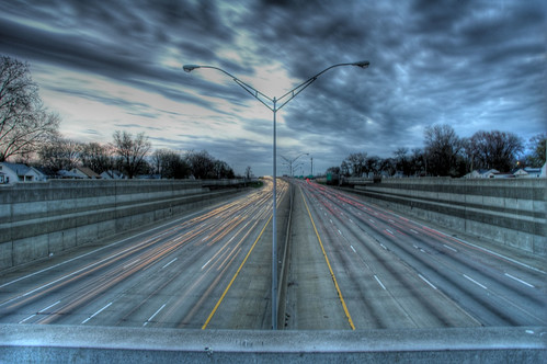
By rob2655 of Flickr.
Setting it inground would be rather expensive - I think it's extremely unlikely that the benefits would outweigh the costs. Not only is there the cost of all the excavation, retaining walls and sump pumps, but there's also a lot of existing stormwater pipes that it would get in the way of. And do you envisage closing South Road as this is done? The Anzac Highway underpass was, for good economic reasons, constructed with South Road remaining open - but I don't see how it could be left open if the horizontal alignment remained constant.Set inground, but remains open-air. Side acess roads would still remain at ground level and have on-off ramps at all major intersections. It would allow for several bridges to be built over to connect all the side streets, which technically is a flawed obstacle to the 'traffic-light free' plan they currently have for south road, as this traffic would still continue to create minor congestion.
And we don't need to connect all the side streets. The sensible thing would be to have lots of footbridges and some of the side streets bridging South Road, and others connecting to South Road. Right turns would be banned, but there's no reason to prevent left turns, assuming the speed limit isn't raised. However, if councils and residents want to close some of the side streets, there's no reason not to.
It wouldn't fit in very well with the N side of the Anzac Highway underpass, as there's a creek in the way. And I don't think there'd be any point of depressing the road near the Sturt Road underpass. As for the Port/Grange road tunnel, it would make more sense to lengthen the tunnel than to keep the road at the ends of it in an unnecessarily long trench.Its a concept which would integrate will with the U/C anzac highway underpass and Sturt road underpass, and the Port/Grange road tunnel.
Just build it wrote:Bye Union Hall. I'll see you in another life, when we are both cats.
Who is online
Users browsing this forum: No registered users and 17 guests